Jamb 2008 Geography Past Questions And Answers
1
Which of the following Nigerian towns is likely to experience frequent cases of coastal erosion?
- A. Burutu
- B. Akankpa
- C. Lokoja
- D. llesha
2
Unemployment is at a high level in West African cities because?
- A. there is a large youthful population
- B. many of the dwellers are skilled
- C. many of the dwellers are unskilled
- D. industrialization is at a slow pace
3
A state in Nigeria notable for hydroelectric power generation is?
- A. Plateau
- B. Niger
- C. Adamawa
- D. Kaduna
4
Wheat is cultivated through irrigation in Nigeria in?
- A. Kano state
- B. Kogi state
- C. Kaduna state
- D. Nasarawa state
5
Rocks often develop cracks when they are exposed to?
- A. compression and movements
- B. joints and faults
- C. compression and tension
- D. joints and cracks
6
Zuma rock, Zaria and Kano inselbergs in Nigeria are within the confines of the?
- A. Western uplands
- B. Eastern highlands
- C. North central highlands
- D. North-east highlands
7
Which of the following operations is common to both chain and prismatic compass surveys?
- A. Baseline determination
- B. Forward bearing reading
- C. Backward bearing reading
- D. Offset measurement
8
Tress in the mangrove forest have aerial roots because they?
- A. have to absorb water
- B. need more air than water
- C. have to absorb nutrients
- D. do not require much water
9
Sydney, Hong Kong and San Francisco have attained considerable importance because of their function as?
- A. important railway junction
- B. capital cities
- C. seaports
- D. cross roads
10
The likely human activity in the northern part of the map is
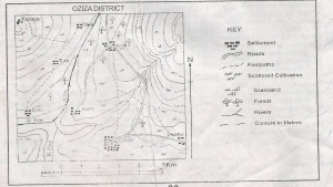
- A. Lumbering
- B. Fishing
- C. Mining
- D. Quarring