Geography Past Questions And Answers
2691
The symbol A950 to the north-east of IREWA is
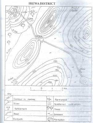
- A. bench mark
- B. spot height
- C. beacon
- D. trigonometrical station
2692
Which of the following may be not solve the problem of over-population?
- A. Increase in food production
- B. Birth control
- C. Increase in the area extent of towns
- D. Reduction of agricultural land
2693
Which of the following is the most important weathering process in Karst regions?
- A. Hydrolysis
- B. Oxidation
- C. Hydration
- D. Carbonation
2694
The predominant systems of agriculture among rural farmers in Nigeria is
- A. terrace farming
- B. irrigation farming
- C. plantation agriculture
- D. bush fallowing
2695
Sun-dial is used for recording the?
- A. amount of sunshine in a place
- B. duration of sunshine in a place
- C. position of the sun in a place
- D. intensity of sunshine within a period of time
2696
The area marked P is
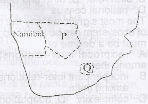
- A. Zambia
- B. Swaziland
- C. Lesotho
- D. Botswana
2697
In which of the following types of vegetation would cork oak and Aleppo pine be found?
- A. Savvannah woodland
- B. Temperate rain forest
- C. Monsoon forest
- D. Mediterranean woodland
2698
(a) State three reasons to show that the earth is spherical
(b) Describe three effects of the revolution of the earth
(c) Calculate the noon altitude of the sun at the Tropic of Capricorn on June 21
View Discussion (0)WAEC 1990 THEORY2699
The most sparsely populated areas of the world include?
- A. Canada and Eurasia
- B. China and Japan
- C. Japan and Indonesia
- D. Bangladesh and Sri Lanka
2700
What is the scale of the map in statement form?
- A. one centimeter on the map represents half kilometer on the ground
- B. One centimeter on the map represents one kilometer on the ground.
- C. One centimeter on the map represents five kilometers on the ground
- D. One centimeter on the map represents fifteen kilometers on the ground.