Geography Past Questions And Answers
101
(a) Draw a sketch map of Nigeria. On the map, locate and name: (i) Owerri. lbadan and Birnin Kebbi; (ii) Cross River and Fadarna plains of River Sokoto.
(b) Outline four factors that encourage tourism in Nigeria
(c) Highlight three problems hindering tourism in Nigeria.
View Discussion (0)WAEC 2017 THEORY
102
The innermost section of the Earth is the
- A. core
- B. mantle
- C. crust
- D. sial
103
Bush burning affects the atmosphere directly by ?
- A. killing soil microbes
- B. adding to carbon(IV) oxide accumulation
- C. leaving the land surface bare
- D. adding ashes to the soil
104
The major world exporters of wool are?
- A. New Zealand, Uruguay, Australia and Argentina
- B. Australia, India, Paraguay and Argentina
- C. Bristian, Australia, Mediterrance Europe , Uruguay and South Africa
- D. New Zealand, India, Uruguay and Peru
105
An example of an atmospheric resources is?
- A. water
- B. coal
- C. tin
- D. petroleum
106
A settlement where social amenities are easily provided to the community is?
- A. squatter settlement
- B. dipersed settlement
- C. linear settlement
- D. nucleated sttlement
107
What is the direction of IREWA and Oki?
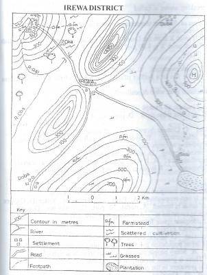
- A. North-east
- B. North
- C. South
- D. South-East
108
The sequence of events that best describes the formation of sandstone is?
- A. dissolution, denudation and consolidation
- B. extrusion, denudation and deposition
- C. intrusion, granulation and consolidation
- D. deposition, consolidation and cementation
109
The Ruhr coalfield is located in?
- A. Russia
- B. Germany
- C. The U.S.A
- D. Canada
110
Which of the following features is associated with river capture?
- A. Delta
- B. Wind gap
- C. Meander
- D. Levee